
- December 06, 2023
- By Maggie Haslam
In a darkened classroom tucked in the University of Maryland’s Chemistry Building, students cluster around a monitor to analyze a run of shallow, wavy lines punctuated by an occasional upward jump. But what looks like possible signs of life on an EKG is actually potential evidence of the dead, lying deep below an expanse of grass and asphalt just east of Gaithersburg, Md.
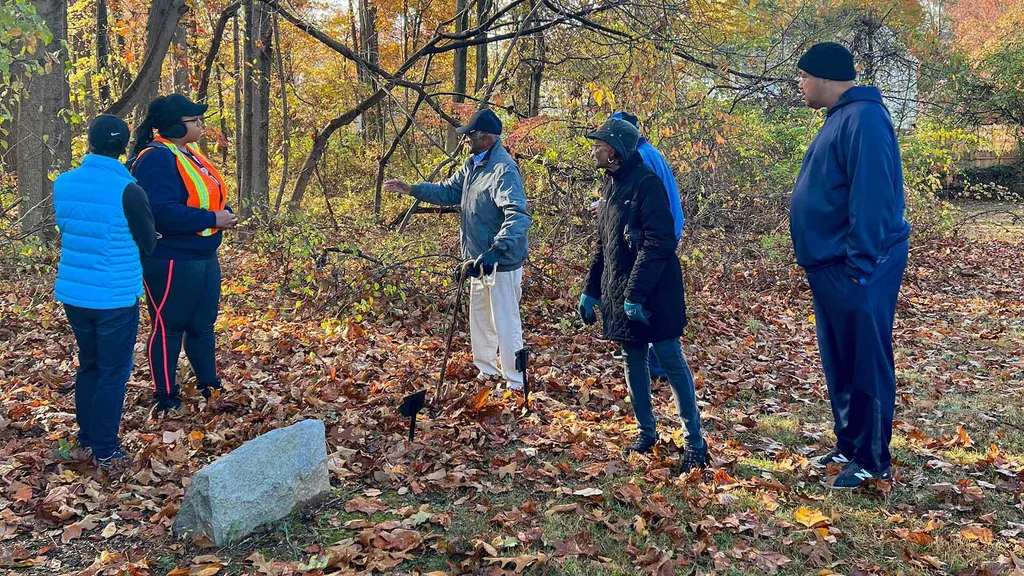
The students are searching for unmarked graves that disappeared from view—and later, memory—with the passage of time and circumstance on the grounds of one of Montgomery County’s oldest African American churches. Commissioned by the historic Emory Grove United Methodist Church with the support of the county and UMD’s Partnership in Action Learning in Sustainability (PALS) program, the project aims to determine the location of the church’s early, forgotten gravesites in advance of redevelopment plans set to reclaim a once-vibrant African American hamlet.
“Projects like this are always useful from a development standpoint, but are also so important to the history and future of this community,” said geology Professor Nicholas Schmerr. “There’s a lot of pressure to get things right.”
The church is one of the last remnants of Emory Grove, a tight-knit community founded by formerly enslaved people freed from nearby farms shortly after the Emancipation Proclamation. Situated on over 300 acres, it was home to 500 African Americans at its peak, boasting a baseball field that hosted Negro League games and a park that held some of the region’s largest Methodist “camp meetings,” often drawing over 10,000 people.
But the promise of indoor plumbing and paved roads as part of urban renewal in the 1960s fractured the community and displaced many of its residents, a nationwide phenomenon of suburbanization that disproportionately impacted Black communities. Over time, the cemetery adjacent to the church fell into disuse; as congregants passed away and pastors moved on, the property’s history was obscured.
Now the church, in partnership with Habitat for Humanity, Montgomery County and the Housing Opportunities Commission (the organization behind urban renewal efforts decades ago) is planning a new mixed-use development project, including affordable housing, on Emory Grove’s land, requiring a better understanding of the property’s history.
Rapid development, said Schmerr, has encroached on community graveyards, particularly African American historic cemeteries, which fall victim to the selling or forfeiting of land, incomplete church records, poor upkeep and eroded markers. A geological survey was beyond what the church could afford, said the Rev. Timothy Warner.
“We knew we’d literally have to put a shovel in the ground next to the church—but what we didn’t know was how far we can go in either direction without disturbing bodies,” he said. “And that’s something I want to avoid at all costs.”
This is the first time Schmerr’s “Field Geophysics” course has taken on a project for PALS, which pairs students and faculty with communities, county and state government agencies to address environmental, social and economic sustainability challenges. The findings generated by the students, a mix of undergraduate and graduates, will be integral to future development.
[Research at the Frozen End of the Earth: On Coast of Antarctica, Geology Team Investigates Ins and Outs of World’s Largest Ice Shelf]
Through global positioning systems and conversations with a former pastor of the church, the students were able to home in on what portions of the property most likely held unmarked graves. Using ground penetrating radars (GPR) contributed by UMD’s Department of Geology, NASA Goddard Space Flight Center and Montgomery County, students collected data in November within the property’s subsurface, down to roughly 3 meters below the surface.
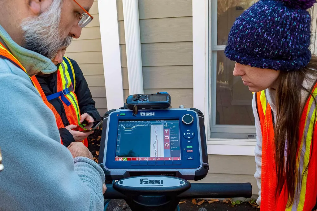
Similar to finding aircraft in the sky, GPR sends radio waves into the ground, which then reflect off features like bedrock, changes in soil and metal. In terms of locating graves, GPR cannot pick up wood, but can detect the differentiation between wood and an air gap, as well as soil disturbances. It’s a time-consuming process; the machines, which resemble lawn mowers, must be slowly pushed along the surface, taking scans at 25-centimeter increments.
“The machine will get mad at you if you go too fast,” said geology master’s student Megan Perry, who walked close to two miles with the GPR machine during the site visit. “It took hours to do and requires a lot of focus and notetaking, but it’s very rewarding.”
Now, her team is deciphering the 116 files it gathered for its section of the property. “It could take a few minutes,” she said, “but it could take a week. That’s how research works!”
This type of survey, said Schmerr, can be vital to development projects; beyond the gravesites, the report will also identify where utilities and water mains are buried, as well as bedrock, which provides a more solid building foundation.
Early analysis shows several potential anomalies on the property, with more work to be done in the coming week. The students will present their final report to Warner, the community and county officials on Dec. 19. Schmerr has applied for a grant from the new Do Good Campus Fund to conduct more scans of the property, including another site in the church’s current cemetery known to hold several unmarked graves.
While Schmerr is confident his students are honing practical skills they can use in their careers, he hopes that as they translate those wavy lines, they’re also seeing the bigger picture.
“This is about taking data and transforming it into something that’s meaningful to the client,” he said. “And it's critical to preserving this part of our region’s history.”