
- July 19, 2023
- By Chris Carroll
Indiscriminate shelling along the front lines of Russia’s invasion of Ukraine has seeded farm fields and towns with untold numbers of unexploded munitions. Now University of Maryland geographical sciences researchers are combining satellite imagery with deep learning, a form of artificial intelligence (AI), in hopes of preventing a deadly harvest.
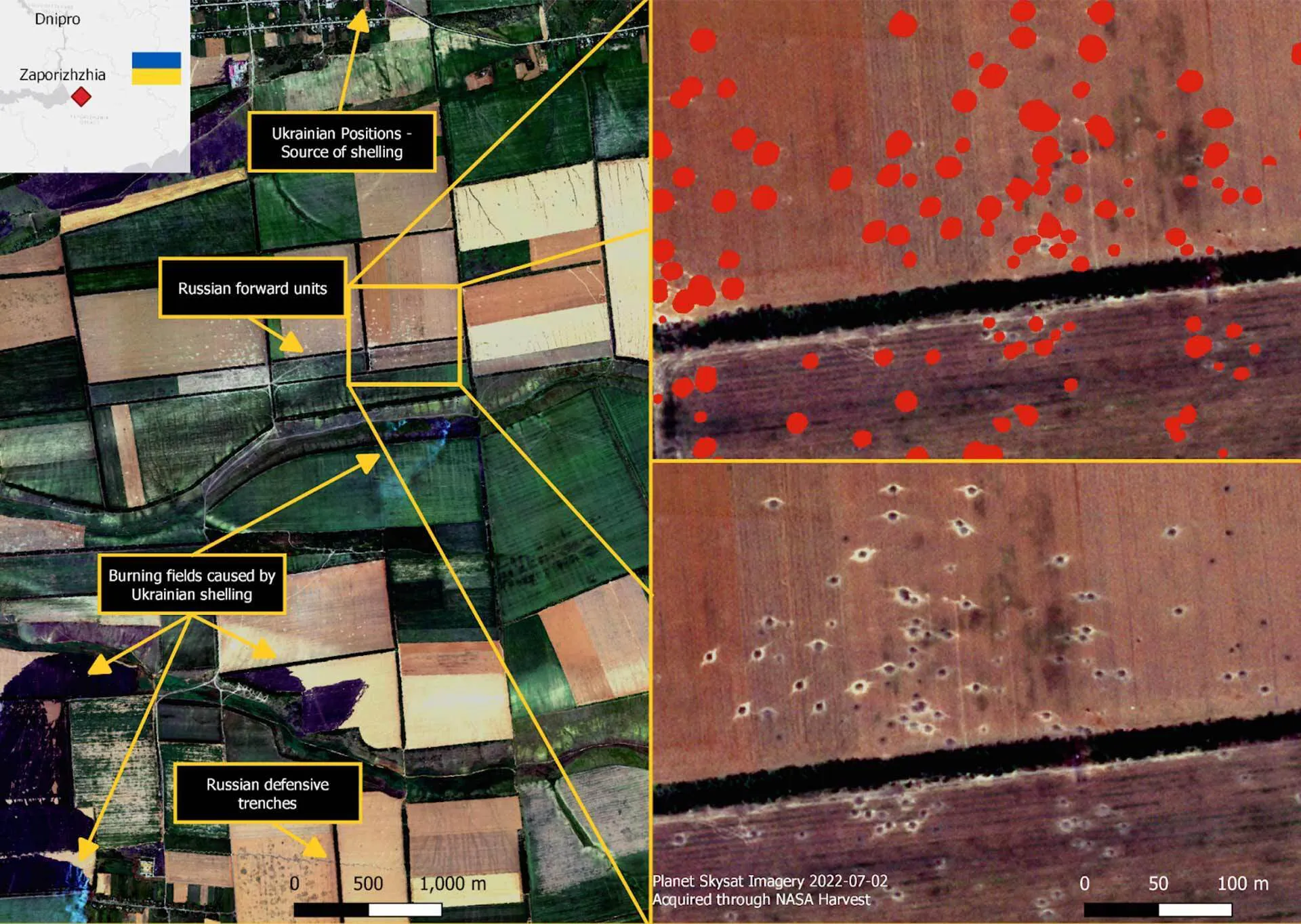
Their system has already mapped about 2.5 million artillery strike craters in a 500-mile arc stretching across the country’s heavily agricultural south and east—data that government and nongovernmental demining organizations can use to prioritize the most dangerous areas for cleanup when the tides of battle allow.
There’s no solid information on failure rates for the Soviet-era artillery shells both sides have used, but estimates range from 10% up to 30%, says Associate Professor Sergii Skakun, co-author of a recently published paper on the system in the journal Science of Remote Sensing—meaning nearly 1 million unexploded shells might be lying across the region they surveyed.
A Ukrainian scientist with expertise in satellite operations to monitor agriculture and environmental conditions, Skakun said that farmers in the region face a particularly frightening choice between bankruptcy and injury or death.
“When it’s time to plant you have to plant, or you have no income,” he said. “You can’t wait until it’s safe. But you are in danger of being blown up in your tractor.”
Russia’s artillery doctrine is to saturate target areas with an enormous quantity of unguided munitions; estimates of daily shell expenditure on the Russian side during heavy offensives are as high as 60,000 shells per day. Anecdotal evidence suggests incidents involving unexploded ordnance are frequent; co-author Erik Duncan, a Department of Geographical Sciences faculty specialist who studied unexploded artillery in Ukraine for his master’s degree, said during an interview last week that he’d spoken to a demining official in whose district a tractor had hit a mine that morning.
Failure to adequately clear leftover ordnance once fighting stops would leave Ukraine facing the same dire straits as countries in former war zones from the Balkans to Southeast Asia to the Middle East. Global estimates of yearly civilian deaths from unexploded ordnance (UXO) range from 10,000 to 20,000—many of them children, according to UNICEF. The United Nations child welfare division already had classified Eastern Ukraine as one of the most mine-plagued spots on Earth as early as 2017, when regional separatist fighting in Ukraine had not yet morphed into the full-scale invasion Russian President Vladimir Putin launched in early 2022.
Duncan trained the deep learning AI system (which mimics certain human cognitive functions) to find artillery craters by manually labeling 18,000 of them himself in high-resolution satellite imagery. Now, using commercial data from Planet Labs’ SkySat and Maxar’s WorldView satellites—which can see details as small as 30 to 50 centimeters—it can quickly point officials in charge of monitoring large areas directly to fields, villages and other areas that are likely bristling with UXO. This avoids the labor-intensive eyeballing of satellite data before the the demining process begins.
“What makes this valuable, in simple terms, is the efficiency and the statistical ability,” Duncan said. “You can certainly see the craters and label them manually if you want, but it’s a pretty big ask if you wanted to zoom out and cover 40,000 square kilometers and determine what’s been hit and what hasn’t been hit.”
While the system can’t directly detect mines—which Russian forces have been placing in extensive defensive lines to impede an ongoing Ukrainian effort to retake territory—the researchers trained it to see military vehicle tracks on open ground that were clearly not made by farm equipment. That’s an indication of military operations and a clue that anti-tank mines were placed nearby.
The researchers were able to obtain the satellite data through UMD’s participation in the NASA Harvest Program, which monitors global croplands and is based in the Department of Geographical Sciences under the directorship of Research Professor Inbal Becker-Reshef, and through NASA’s Commercial Smallsat Data Acquisition (CSDA) Program.
Next steps include expanding the system’s geographic coverage and obtaining newer imagery, as well as refining the system into a finished platform that the operators can directly use, Duncan said—in Ukraine as well as other places around the globe that have recently been shelled. It might even be possible, Skakun said, to use a version of their system to help detect much older artillery craters from historical conflicts, although it would require lots of additional research to spot features that have been obscured by the passage of years, he said.
“Because of our access to incredible computing power that exists at the University of Maryland, our access to the satellite data, and our GIS and computer science knowledge, we’re in this kind of special niche,” Skakun said. “We can provide this valuable information to the (demining) operators and the government they couldn’t get by themselves, and help save lives.”