- July 29, 2025
- By John Tucker
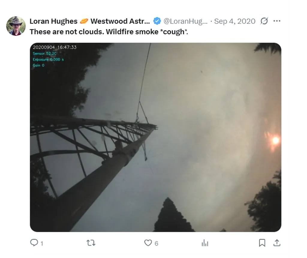
One afternoon in September 2020, Loran Hughes noticed an ominous plume forming in the Southwest Oregon sky, shrouding the sun in darkness. The 62-year-old amateur astrophotographer, who had weak lungs, uploaded an image from his sky camera and fired off a tweet (below).
“These are not clouds,” it read. “Wildfire smoke *cough*.”
Hughes feared the blaze was headed his way, as winds began spitting out debris. “We had ashes as big as my hand falling,” he recalled in an interview.
The flames spared Hughes’ house, but four days later the Almeda fire, the worst in Oregon’s history, destroyed more than 2,600 others, including one belonging to family members. It also fit a pattern: Wildfires have doubled in frequency and intensity in the last two decades, burning with particular ferocity in the United States, where they have recently claimed hundreds of lives in Los Angeles, Texas and Hawaii. Authorities often find themselves chasing moving targets as wildfires race across landscapes and windblown firebrands create flare-ups far from main blazes, sowing confusion and delaying evacuation orders where people need it most.
But social media posts like the one authored by Hughes could potentially cut through this operational haze, helping first responders ward off damage and save lives, according to University of Maryland postdoctoral researcher Zihui “Helen” Ma, who recently developed a method relying on artificial intelligence (AI) to amass and analyze wildfire-related posts in real time.
As an outbreak ebbs and flows, so does public alarm on platforms like Facebook—a digital signpost for the real-world path of destruction, she said.
“Even during emergencies, people have time to take a picture and post it online,” said Ma, who conducts her research through UMD’s Department of Civil and Environmental Engineering.
For Hughes, that meant documenting smoke so thick, he could barely see his neighbor’s farmhouse 100 yards away. “I just wanted to show how particularly bad it was that day,” he recalled. “We didn’t know when this thing was going to stop.”
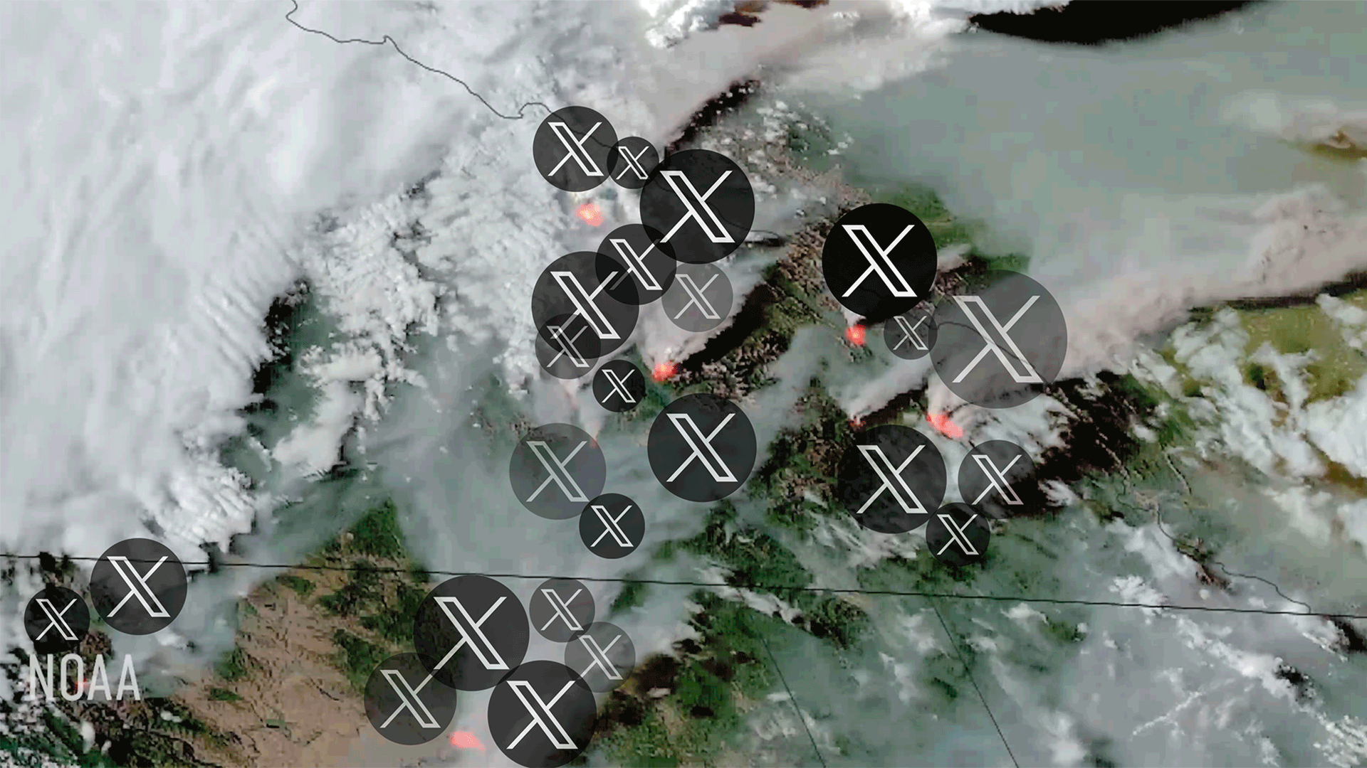
Ma demonstrated her strategy by combing through a huge volume of data from X, then known as Twitter. She captured each mention of “wildfire” in California, Oregon and Washington over one month in 2020—a year when fires ripped through more than 10.2 million acres of land, causing $20 billion in damages and killing at least 37; that netted 151,682 posts.
Next, she used machine learning—a type of AI that can learn from data, spot patterns and draw conclusions—to organize the mass of Twitter information into six topics: health impact, damage, monitoring, evacuation, humanitarian aid and recovery. If a post included words like “acre,” “death” or “missing,” for instance, it was sorted into the damage category.
Hughes’ tweet included the word “smoke,” so it joined the health impact category.
After pinpointing literal hotspots, Ma sought to track them over time and space, so she borrowed a tactic used by epidemiologists to measure disease spread. Applying mathematical calculations to her social media data, Ma captured the speed and breadth of each fire, pairing it with urgency levels reflected in Twitter posts, and produced maps and graphs outlining the deadly trajectories.
“First responders need to act quickly to move people, and to do that they need data—not for next year’s planning but for today,” said Gregory Baecher, UMD professor of civil and environmental engineering who collaborated with Ma on the research.
Traditionally, authorities rely on satellite data to battle major wildfires—a method limited by conditions like smoke and clouds, Ma said. By tapping into ground-level information immediately, her tool could provide critical backup, as fires will burn longer and even more extensively over the next 30 years, experts say.
“This is great news for residents who know there is some risk but also a solution that could save them,” said Yuki Miura, a mechanical and aerospace engineering professor and disaster risk-management expert at New York University, where Ma serves as faculty fellow in addition to her UMD post.
Ma plans to fine-tune her technique so it can be deployed in a live scenario. The odds of that happening will only grow as outbreaks start sooner and end later in the year.
“At this point we’re not just dealing with fire season,” she said. “It’s starting to feel more like fire year.”
UMD Research Changes Lives
At the University of Maryland,
scientists and scholars come together to spark new ideas, pursue
important discoveries and tackle humanity's grand challenges—improving
lives in our communities and across the globe. See more examples of how
UMD research changes lives at today.umd.edu/topic/research-impact.