- April 23, 2024
- By Maggie Haslam
CATHERINE NAKALEMBE STOOD shin-deep in the middle of an Eastern Ugandan river on a sweltering, blue-sky day in 2014, peering out from beneath her wide-brimmed hat as she surveyed the farmland before her. A geographical sciences assistant professor and expert in satellite remote sensing, she’d seen this field before—from space. Approximately 350 miles up, satellites could capture the patchwork tapestry of browns and greens that make up Africa’s agricultural landscape. But the images they beamed back couldn’t tell Nakalembe if the crop in front of her was maize or wheat.
As the Africa program lead for NASA Harvest, an international consortium commissioned by the space agency and led by the University of Maryland, those details were critical to her work. Without knowing the crop type, computer models couldn’t monitor how it will fare against a spike in temperature or a projected wet season, or inventory what’s growing in the region. So Nakalembe tromped across Eastern Africa’s small farms—often no more than three acres each—every July and August from 2010 to 2016 to document its fields.
“I walked so many miles, I was in such great shape,” she says. “It was time-consuming and so hard, but it’s what was needed.”
Much of Nakalembe’s own orbit, she says, has been shaped by fateful encounters, people and timing: from her journey to UMD to her path home to fight Africa’s food crisis. And as earth-circling satellites piled up growing mountains of data, she knew she couldn’t singlehandedly teach them to “see” African agriculture with her cross-country treks. It would take another chance event—and on a truly global scale—to literally drive her team to a solution.
“A lot of the things that have happened in my life are by chance,” she said. “But maybe the chances just add up.”
TWO YEARS BEFORE THAT WOULD HAPPEN, in 2018, two cyclones drenched the desert sands of the “Empty Quarter,” a barren expanse straddling Saudi Arabia, Yemen and Oman, awakening generations of locusts to breed and wage a ravenous campaign. Deafening swarms stretching to the horizon laid waste to crops and pastureland over six countries in East Africa, plunging the already food-insecure region into crisis.
Locust plagues and other extreme events, from floods to drought, have battered Africa’s agriculture industry for centuries, exacerbated its high rate of hunger and fueled economic and political instability. But this crop of airborne pestilence, which lasted until 2022, stemmed from irregular circulation and temperature patterns in the Indian Ocean likely caused by climate change.
Extreme events, which are expected to increase as global warming continues, deliver profound socioeconomic blows. According to the consulting group McKinsey and Co., agriculture is Africa’s largest economic sector, accounting for more than $100 billion annually and employing over half the continent’s workers. Meanwhile, nearly 800 million Africans— roughly 60% of the population—are food-insecure. In 2022, a person died every 36 seconds in drought-stricken East Africa.

Nakalembe’s work is central to UMD’s effort to advance the use of remote sensing and artificial intelligence (AI) to monitor and protect global food security. In Africa, she has established herself as a trailblazer: Over the past 14 years she has combined her geographical expertise with the demanding, often improvisational nature of field work to provide governments with the tools to know what’s growing where, and the ability to respond to and head off crises on a continent where deadly food shortages occur with numbing regularity.
“This research is about getting out in front of some of the worst events,” says geographical sciences Distinguished University Professor Christopher Justice, who has worked with Nakalembe since 2010. “And it’s about getting quick, actionable information to those who need it to minimize the impacts on the population. In this respect, Catherine’s grabbing the bull by the horns.”
TWO DECADES BEFORE Nakalembe was pointing satellites toward Africa, she was taking an interest in its diverse ecology while walking each day between school and her family’s tidy, plastered mud house outside Kampala, Uganda’s capital. A chance conversation with a family friend who worked at Makerere University in Kampala—and her knack for geography and math—helped her win a fully funded spot in its new environmental science program. After her undergraduate degree, her sister encouraged her to apply to graduate school in the U.S. Each week, she made the four-mile trek from her home to the local U.S. Embassy’s library to research schools and take practice tests.
With help from family, friends, acquaintances and university administrators, she pursued a master’s at Johns Hopkins University, then went on to get her Ph.D. at Maryland. At a faculty event in her first semester she met Justice; he had just launched UMD’s Group on Earth Observations Global Agricultural Monitoring Initiative (GEOGLAM) in Africa, which preceded NASA Harvest in applying remote sensing to develop policy around agriculture and global food security. At the time, Nakalembe’s knowledge of agriculture was limited to growing maize outside her parents’ house, but her geographical expertise, coupled with knowledge of her home country, was the missing piece the initiative needed.
Three sentences into their first conversation, Justice, who would become her doctoral adviser, asked her, “How would you like to go back to Uganda?”
Nakalembe began work on her dissertation in Uganda and projects for GEOGLAM in countries including Mali, Ethiopia and Kenya in 2010. With funding from organizations including the Gates Family Foundation, she collaborated with government ministries to develop agricultural risk analyses and a framework for crop monitoring systems. She quickly learned, however, that what worked in Kenya might not in Tanzania; beyond what was growing in the fields, government structures varied wildly.
But it was less about reinventing the wheel and more about rearranging the spokes. With the launch of NASA Harvest in 2018, Nakalembe synthesized all the work and lessons learned during her years in the field to begin developing a catalog of tools, computer models and data already available through public and private organizations that, in different combinations, could meet each country’s specific needs.
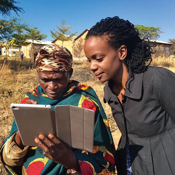
Nakalembe worked with ministries across Eastern Africa to give them critical information, from land use to rainfall amounts. For the first time, they had unprecedented views of the health of Africa’s agricultural industry—but not a complete picture.
WHAT GAVE NAKALEMBE the visibility she needed was the event that shuttered the world: COVID-19. Unable to travel or conduct in-person research, the extensive, on-the-ground network of people she developed through her years in the field—including farmers, field agents, humanitarian groups and ministry stakeholders—proved to be the linchpin to secure a grant to purchase and distribute GoPro cameras, free to any African farmer or field agent willing to send back the pictures they capture.
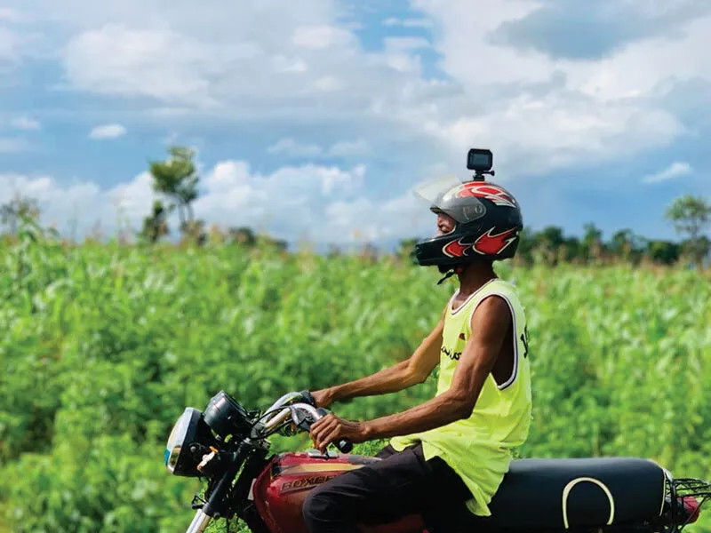
Canvassing the landscape at around 40 mph, the cameras, which are affixed to cars and motorbikes, can rapidly generate pictures of crops and record each location. The images are fed to machine learning systems to turn the data from “street to sat,” creating satellite-ready labels that can allow artificial intelligence to eventually recognize crops from space.
When her team ran the first trial in December 2020, it was able to cover 30-40% of Western Kenya in two weeks. Across the continent, it has so far generated over 5 million images—data integral to tracking crop types and growing conditions, while warning of potential droughts, flooding and diseases. The team is now working to perfect yield predictions.
“This real-time information enables ministries to prioritize response efforts early enough before it becomes a crisis,” says Kenneth Mwangi, an agriculture monitoring and early-warning expert with the Intergovernmental Authority on Development in Eastern Africa, who has worked with Nakalembe for six years. “And that’s how we really benefit from some of the work being done by UMD, Catherine and NASA Harvest.”
ASK NAKALEMBE what success looks like, and she eschews the recognition she’s earned on the international stage, including the $1 million Al-Sumait Prize for African Development in 2022 that she split with a co-awardee and the Africa Food Prize in 2020. Instead, she’ll point to a recent conversation she read on WhatsApp among a crop monitoring team in Kenya. A news article had announced that the ministry was going to dispatch fertilizer to an area that had a measured reduction in production.
“This is to let you know that all the work you’re doing is leading to these types of decisions,” read a comment from a ministry official.
Having countries in charge of their own destiny, says Nakalembe, is the key to reversing the food crisis. She sees Harvest’s role as setting up and supporting the systems, but it is up to the governments to provide the human capacity to run them, generate the communications that lead to policy and collaborate across their borders.
“This is more powerful than any remote sensing,” she says. “It’s a seed that then yields this connectivity, and having a place where they can show, ‘This is what’s happening.’”
Grants helped Nakalembe and her team collect the initial data; but collecting it over multiple years will help them build better models, which will lead to better outcomes for Africa. That will require more money. In the meantime, she will cart another box of GoPros home from her office—where boxes of them cover every surface—for her twin sons to assemble. She will keep delivering what’s needed.
“The fact that she’s utilizing her skills to impact her home country is particularly meaningful, but for her I think it brings some responsibility,” says Justice. “You have to find good people who want to make a difference, and Catherine’s one of them.”
Topics
Research