
- February 06, 2014
- By Liam Farrell
With a Nor’easter crawling toward his College Park office, Maryland geographer Matthew Hansen is thinking about traveling into untouched tropical wilderness. On a computer screen is a large swath of green, a natural forest in the Congo, with a small black dot in the middle. Some of the forest has been burned along a nearby river, but the black dot—a lake—is in the ever-shrinking, unsullied portion of the world’s ecosystem.
“Oh my God, if I go into a primary forest, it’s freaking awesome,” he says. “It’s the closest thing for me that comes to church.”
In a sense, he says, going there would “almost be sacrilegious.” It’s the basic conundrum of the loving observer. Like a surfer regretting the impulse to slice his board through a perfect wave, there is the knowledge that enjoying nature inevitably changes it.
The comparison is partially conjured by Hansen’s lanky frame, stubbled beard and casual voice, but it’s also because Hansen will be a big part of future efforts to preserve nature. The professor of geographical sciences recently created a first-of-its-kind digital map that represents a leap forward in understanding how the world’s trees are disappearing and is a cornerstone of efforts to get governments around the world reliable environmental data.
“It’s the first time that we’ve seen global forest cover change in such fine detail,” says Chris Justice, chair of Maryland’s Department of Geographical Sciences. “This is really a breakthrough in our field.”
The map, produced with more than 650,000 satellite images and a team of 15 researchers from Maryland and other universities, Google and the federal government, catalogued the amount of forest lost and gained between 2000 and 2012. What it shows is a net loss of 1.5 million square miles of forest.
The destruction is personally disappointing to Hansen. Yet the former Peace Corps volunteer doesn’t parachute into other countries and hector the locals about saving their national resources. With so few doing accurate monitoring of their own, what’s needed first is a basic understanding of what’s happening to the world’s trees.
“Just this idea that, man, there are very few forests that are left alone,” he says. “We’re really good at appropriating landscapes and bending them to our will.”
Patience in Personality
Hansen feels comfortable under any circumstances in traveling to research forest cover, and the list of local dishes he has eaten—rats, snakes, crickets, termites and monkeys in the Congo—would impress even those with iron stomachs.
“They were all good,” he says. “Give me something to eat, and I’ll eat it.”
Hansen grew up outside Indianapolis in Carmel, Ind., and after a false start at Duke (“My dad didn’t like the return on investment”) ended up getting a degree in electrical engineering from his mother’s alma mater, Auburn (“You don’t know you’re a Northerner until you go there”).
After graduating in 1988, he joined the Peace Corps and spent several years teaching fish farming in what was then known as Zaire. Hansen lived in a mud hut—“just way out there in the middle of nowhere”—and caught malaria immediately, the first of five bouts with the disease. He went months without talking to any Westerners.
“I lived in this small village and the people there fed me for two years. They basically took care of me,” Hansen says. “I learned that we are peers with everyone around the world.”
Needing a path after his Peace Corps service ended in 1991, he began to look into studying geography. Maps had always been a source of interest, and Hansen had often found himself immersed in atlases.
After Hansen earned a master’s in civil engineering and a master’s in geography at the University of North Carolina at Charlotte, John Townshend, now the dean of the College of Behavioral and Social Sciences and a professor of geography at Maryland since 1989, brought him to College Park to work on global maps of land cover.
“It became quickly apparent to me, he is highly intelligent,” Townshend says. “He’s not a linear thinker. He’s highly innovative.”
Tom Loveland, a senior scientist and co-director at South Dakota State’s Geographic Information Science Center of Excellence, has known Hansen for two decades. Loveland admired his “curiosity that knows no bounds” and eventually persuaded him to come to South Dakota so they could work together.
“I love sitting down and talking books with Matt,” he says. “That’s part of his success. He’s not focused strictly on the core of his work.
“I gave up trying to keep up with him.”
Finding a Balance
The continents are black and the oceans are gray on the computer screen, the better to see vibrant green showing the world’s forests and bright red, blue and purple, respectively, indicating losses, gains and places with both.
Flicking over the map with his mouse, Hansen stops occasionally to share insights about nature, man and the intersection of the two.
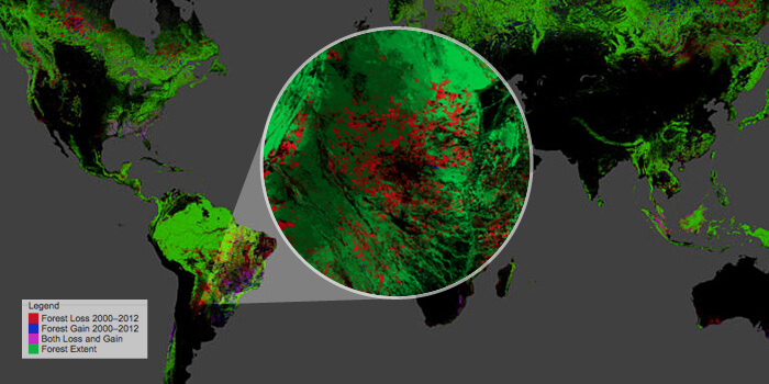
See that red wedge shape cleaving into the southwest part of France? The trees were knocked down by the winds of a powerful derecho. See that red streak in Alabama? That’s the path of the 2011 Tuscaloosa-Birmingham tornado. See those flecks of red along the west coast of Canada? Some of that is from a mountain pine beetle infestation sprung by mild winters. And the map has more: forest fires in Siberia; logging in Malaysia; the creation of cattle ranches in Paraguay.
In a few minutes, Hansen shows the necessity of understanding our world in its smallest and largest parts. For all the conservation success of a country like Brazil, whose declining rainforest drew decades of intense scrutiny, the losses in other countries can make it a partial victory at best.
Loveland says this is what makes Hansen’s work so valuable. Whereas some researchers would approach the map as an image-processing exercise, Hansen analyzes it through the lens of an “old-time geographer” as well. In other words, the human realities on the ground aren’t an afterthought to technological achievement.
“Matt has shown we can start mapping at the scale that human decisions are made,” Loveland says. “No matter what area of the world you pop up, Matt’s got a story.”
Hansen’s goal is getting everyone to have the same factual foundation. It’s important that a hydrologist in Vancouver can find out that a privately owned part of a watershed is being logged or a national park ranger in Cambodia can get accurate pictures for a meeting with the minister of the environment.
His next steps are delineating what exactly caused tree loss in different areas, be it fire, disease, logging or storms, and then updating the map to reflect the latest data. The next step for locals, Hansen hopes, is using the map to get involved in preserving what’s left.
“Because I lived in a village in Congo, I understand that there have to be livelihoods,” he says. “But, you know, let’s make them sustainable—let’s do it intelligently.” TERP